Meteorological environment monitoring equipment supplier
Insist on doing high-precision customer favorite technology products

Meteorological environment monitoring equipment supplier
Insist on doing high-precision customer favorite technology products

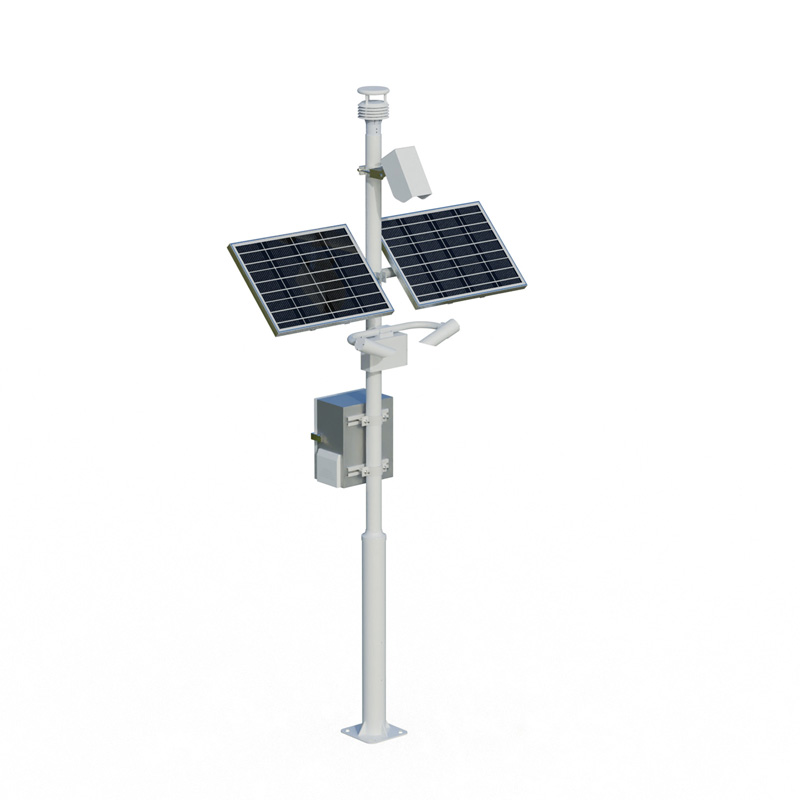
Road Weather Information System can monitor meteorological elements such as visibility, wind speed, wind direction, temperature, humidity, atmospheric pressure, rainfall, and road surface conditions in real time. This system aims to improve the intelligence level of urban roads and traffic efficiency, optimize traffic management through data-driven approaches, reduce accident risks, support sustainable urban development, and contribute to a safer and more efficient travel environment.
Road Weather Information System is a sensor network-based technology solution specifically designed for real-time data acquisition of urban road environments. By integrating multiple sensors, the system continuously monitors key meteorological elements, including visibility, wind speed, wind direction, temperature, humidity, atmospheric pressure, rainfall, and road surface conditions. This data provides fundamental information for urban traffic management, helping to improve the intelligence level of roads and overall traffic efficiency. In modern cities, traffic congestion and safety issues are becoming increasingly prominent, and the application of Road Weather Information System has become an important tool for addressing these challenges.
The visibility data monitored by the system is crucial for road traffic safety. Low visibility conditions, such as fog or heavy rain, can easily lead to traffic accidents. Through real-time monitoring, the system can provide timely warnings, assisting traffic management departments in adjusting traffic light controls or issuing warning information. Wind speed and direction monitoring helps assess the impact of crosswinds on vehicle stability, especially on bridges or open road sections. Temperature and humidity data reflect the risk of road icing or slipperiness; when temperatures are near freezing and humidity is high, the system can trigger anti-skid measures. Atmospheric pressure changes may be related to weather system shifts, providing a reference for predicting rainfall or storms.
Rainfall monitoring is directly related to road drainage and water accumulation. Heavy rainfall can lead to road flooding, affecting vehicle traffic and safety. Road Weather Information System uses real-time rainfall data, combined with road condition sensors, to detect water depth or slipperiness. Road condition monitoring typically involves detecting road surface temperature, slipperiness, and icing or snow accumulation. This information helps traffic management centers assess road availability and initiate de-icing or clearing operations when necessary. All monitoring data is transmitted wirelessly to a central processing platform for real-time analysis and storage.
Improving the intelligence level of urban roads is one of Road Weather Information System's core objectives. Intelligence is reflected in data-driven decision support. After analyzing the collected meteorological and road condition data, the system can automatically generate reports or trigger response mechanisms. For example, when icy roads are detected, the system can automatically notify maintenance departments to apply salt or issue speed reduction warnings to drivers via variable message signs. This automated response reduces delays caused by human intervention and improves management efficiency. Furthermore, the data can be integrated with intelligent transportation systems to optimize traffic light timings and adjust green light cycles based on real-time traffic conditions, thereby alleviating congestion.
Improved traffic efficiency relies on the accurate information provided by Road Weather Information System. Through real-time monitoring, traffic management centers can more accurately assess the condition of the road network and predict congestion points or accident risks. For example, in low visibility or strong wind conditions, the system can suggest reducing speed limits or closing high-risk road sections. This helps reduce traffic accident rates and shorten emergency response times. Simultaneously, data is shared with navigation applications or in-vehicle systems to provide drivers with real-time traffic suggestions, optimize route selection, and reduce travel time. In the long term, the historical data accumulated by the system can be used for traffic planning, identifying bottleneck areas, and improving infrastructure design.
The application of Road Weather Information System also extends to the field of urban sustainable development. By optimizing traffic flow and reducing vehicle idling and congestion, the system indirectly reduces fuel consumption and emissions. Monitoring data can also be used for climate adaptation research, helping cities cope with extreme weather events. In terms of safety, the system reduces the probability of weather-related accidents through early warning mechanisms, protecting the safety of pedestrians, cyclists, and drivers. In practical deployments, the system is typically compatible with existing traffic management platforms, ensuring low-cost integration and scalability.
In summary, Road Weather Information System provides a scientific basis for urban road management by monitoring various meteorological and road condition factors in real time. Its functions directly support intelligent upgrades and improved traffic efficiency, relying on empirical data and technological applications rather than metaphors or anthropomorphic descriptions. As urban traffic demand grows, this type of system will become a key component of smart city construction, driving a safer, more efficient, and environmentally friendly travel experience. In the future, technological advancements may further expand monitoring capabilities, but the core objective remains improving the reliability and responsiveness of road services.
Sales Manager:Ms. Emily Wang
Tel, Whatsapp:+86 15898932201
Email:info@fengtutec.com
Add:No. 155 Optoelectronic Industry Accelerator, Gaoxin District, Weifang, Shandong, China